FROM THE HEATH TO THE BANKS OF THE TAGUS
Distance: 10 km; Duration: 3h;
Degree of Difficulty: Easy
Trail departure point: Center of Chamusca – Jardim do Coreto
Coordinates: 39.357458, -8.481264
Beginning at the Jardim do Coreto (the garden with the bandstand) located in the centre, start discovering the history of this town, the heaths of Ribatejo and the banks of the Tagus River. Thanks to its figure-of eight shape, you have a number of options when you do this walk. There is the full version option that we describe here, or one that focuses on the heaths or yet another that lets you do a short, flat walk visiting only the riverside fields. It is easy to park at the starting point and there is a café too.
With the bandstand on your right side, keep going straight ahead, crossing the garden and beginning to climb Marquês de Carvalho Street.Go along this entire street and always keep going straight ahead for one kilometre until you reach the outskirts of the town centre, ignoring the various streets you will see as you go. At the end of the asphalt section you will come to the start of a dirt road that goes to the field. Here you will find the beginning of a section that is one kilometre long and goes along a well-preserved grove dotted with stone pines. You can see several types of animals and plants along the way, including French lavender (Lavandula stoechas), a purple, aromatic plant that is very much appreciated by both people and bees.
At the end of the grove, you will see a patch of eucalyptus trees on your left. Keep going straight ahead for another 900 metres and when the road suddenly divides into various dirt roads, take the first right. Keep climbing, always going along this main road and ignoring all minor access points that you will see along the way. For some 500 metres you will see open countryside with brush on your left while on your right the patch of eucalyptus trees continues. Farther ahead you will once again have the eucalyptus trees on both sides of the road for another 500 metres. When the road forks, keep right, following the main one along the ridge. This is the highest part of the trail, offering a panoramic view that reaches as far as Santarém and the mountains to the north of the Tagus River, which accounts for its name of Cabeça Alta (high peak). Along this section you will once again see the beautiful fields of the native heath in the form of a sparse cluster of cork oaks, olive trees and fig trees, dotted with large clearings and several areas of scrub, used by animal herds and bees as a food source. You will also notice small vineyards dotting the landscape, especially at the end of this section.
Some 1,500 metres ahead you will once again come across an asphalt road as the trail returns to an urban setting. Follow this street for 300 metres and when you reach the fork, go right.
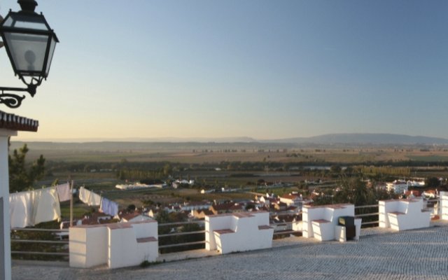
This is where the downhill part of the trail begins, taking us to the river. Go down the street for 200 metres, keeping left when the road forks. Continue straight ahead for 300 metres until you reach the Senhora do Pranto lookout, where an amazing view awaits. This is one of the most beautiful panoramic views you will ever see of the Tagus floodplains. The landscape before you stretches from the rich riverside lands – among the most fertile in Europe – to the heath on the way to the Alentejo region, predominantly occupied by forests. In addition to a large section of the riverfront and the mountain ridges on the other shore, we can easily see the landscape impacted by human activity, with different types of land usage and agricultural activity, creating a mixture of colours that range from the yellow of the sunflower to the gold of the vineyards, or the fleshy red of the tomato plants.
However, it is the green of the corn and other crops that dominates in this patchwork landscape. Here you can admire the Ermida de Nossa Senhora do Pranto church. Facing its facade, go along the street to your left, go down the stairs and then turn left. Follow this street for about 100 metres and then right after the bend turn right until you reach the São Francisco lookout. Admire the facade of the church bearing the same name, commissioned by the Third Order of Penitence in 1741, and which took fifty years to build. Go down the stairs beside the lookout and turn right, following José Taso Street, which ends at Jardim do Coreto (Bandstand Garden).
If you wish, you can now continue on the second part of the trail, which now goes along the riverfront. Facing the bandstand, go along the left side, passing the square of the Igreja Matriz (Main Church). Takesome time to admire the sixteenth-century Manuelinestyle portico before turning left and going all the way to the end of the street, where you will find the square and the Igreja da Misericórdia (Church of Mercy).
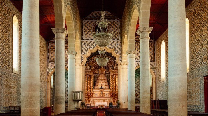
This church was built in the seventeenth century, and this is where the Fogaréus (torchlight) procession is held on the evening of Good Thursday. Cross the national road and go down the street facing the facade of the church; at the end, turn left and at the end of this street turn right, then once again left. Now, keep going straight ahead and after about 100 metres, at the fork, take the road on your right for some 500 metres until you reach the dyke. Here, turn right and keep going for one kilometre along the Tapadão, the name given by the locals to this line of defence that holds back the Tagus floodwaters. Take the time to admire the view of white houses that harmoniously extend in terraces along the slope; from here you can see the lookouts you passed by. Halfway through this section, which coincides with a locally maintained trail, on your left you have a access to the Porto das Mulheres, an area for leisure activities alongside the river, where there used to be a dock that facilitated the river crossing from one bank to the other. Returning to the dyke, keep going until the end and turn right, then keep going straight ahead for 500 metres until you are once again on the national road that crosses the entire town. There is very little visibility here so you have to be careful crossing the road. Follow the street straight ahead, take the second street on the right and then go straight ahead for some 100 metres; this will bring you back to the starting point.


